Hike | Brown's Peak | Four Peaks Wilderness
*This guide was thoughtfully written by Natalie Allen. She is a writer, explorer, and photographer based in Arizona.
TRAIL STATS
- Length: 5.1 miles round-trip
- Trail Type: Out and Back
- Trailhead Elevation: 5,707ft.
- Peak Elevation: 7,659 ft.
- Gain/Loss: +1952 ft.
- Difficulty: Difficult
- Kid Friendly: No
- Dog Friendly: No
Trail Description
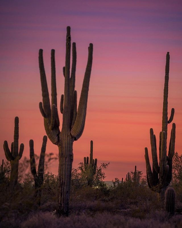
The Four Peaks Wilderness marks itself as a prominent landmark on the eastern skyline of Phoenix. The name Four Peaks is a reference to the four distinct peaks of a north–south ridge forming the massif's summit. The northernmost peak is named Brown's Peak and is the tallest of the four at 7,659 feet, making it the highest peak in Maricopa County.
The view from Brown’s summit is certainly one to remember. One can see about 1/4th of the state of Arizona from the top; in fact, Mt. Humphrey’s in the crevasse of Flagstaff can be seen on a clear day.
A magnitude of diverse wildlife live among the Four Peaks wilderness. It’s particularly well-known for its dense black bear population. Additionally, there have been recorded sightings of ring-tailed cats, skunks, coyotes, deer, javelinas, and mountain lions.
THE HIKE


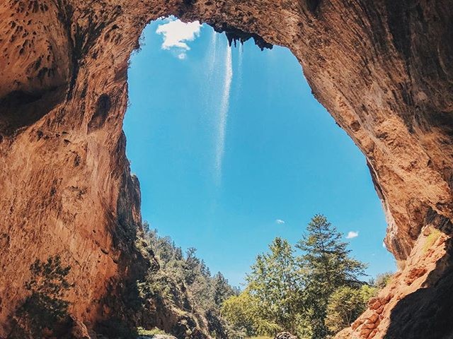
Browns Peak via “Brown's Trail” is a 5.1 mile moderately trafficked out and back trail located near Tortilla Flat, Arizona that features a great forest setting and is only recommended for very experienced adventurers. The trail is primarily used for hiking and is accessible year-round.
Brown’s Peak is special under its own conditions because trekkers hike through the forest, desert, snow covered bushes, and vast vistas over nearby lakes. Although — the most rewarding and equally challenging part of the hike is the final ascent up the treacherous scree chute. This part of the trail should be taken seriously by any hiker, as its steepness and vertical rock walls are no joke. Even avid hikers, such as myself, would consider this chute to be rather dangerous if there’s no sure footing.
Begin the hike at the well marked trailhead. You are looking for Browns trail #133. Beginning as a moderate incline numerous water bars cross the well defined path. The forest is lush and untouched by the Lone fire in the beginning. After a few switchbacks you will pass Snoopy's friend Woodstock. I doubt this is the official name of the rock but you will see the resemblance. Shortly after the green forest gives way to the scorched burn areas.
Continue hiking along the trail and the eastern views of the Tonto Basin and Roosevelt Lake open up. Ground cover was just beginning to surface after the treacherous fire four years ago. Some website say that it will take twenty years for the area to get back to the beautiful forest of trees seen before the fire.
Eventually the trail hooks up with the Amethyst Trail #253. The intersection is nothing to be concerned with, you will most likely not even know as Browns Trail gives way to the Amethyst Trail. Follow the Amethyst Trail for a short distance up to Browns Saddle. You should most certainly take a moment at the saddle to view the Valley of the Sun to the west. Smog usually fills the valley making it hard to see many landmarks. On a clear day you can see Camelback Mountain, Piestewa Peak, and other small landmarks of the valley. The ripples of the desert floor are breathtaking! Even on the calmest day of the year you will feel a breeze on the saddle. This is a good turnaround point for your first attempt.
But for the expert adventure seekers — continue up the chute! Hiking up the scrambling undefined trail to Brown's Peak is confusing at first. After a few attempts you will figure it out. Depending on the route followed you may have to squeeze through a narrow gap, this is the route I prefer. Just after the squeeze a ravine opens up. But the ravine is very steep. Loose rocks make the hike difficult and dangerous. Be careful. Looking up the ravine is the scree chute you are looking to scale to the peak. Move slowly. Be sure you only go up into places you feel comfortable coming down. Remember it's easier getting up than coming back down.
On to the most difficult section. There is a small wall you must scale. Continue on up to a tiny saddle. There is more evidence of a trail from here on. You shouldn't have any problems finding your way over the last series of boulders to the top. June through September you will be greeted by butterflies and ladybugs! You are standing on the throne of the wilderness. If you are equipped with a good knowledge of your surrounding area this is the view you have been waiting for your whole life! You can see as far north as the San Francisco Peaks on an a very clear day. Humphrey's is the highest peak in Arizona but I would recommend Brown's Peak any day!
CAMPING


Ah — yes. When you make your final decent down the infamous view of Brown’s Peak, you’ll meet yourself right back at the trailhead. One of the greatest aspect of this area are the many pockets of perfect camping spots that are spread across miles and miles! My pals and I immediately set up our tent a few miles away from the trailhead and began cooking dinner — we burned lot of calories on the trail. We were hungry.
The Four Peaks wilderness offers a stunning nights rest. Not many people are up in this area near the Brown’s Peak trailhead, so it’s nice and quiet. Be sure to pack up all food and gear safely in the car — back bears are roaming out and about and looking to smell some leftover Mountain House meals!
GETTING THERE
Regardless of where you begin your journey to Brown’s Peak trailhead, the drive there can be a bit harrowing. You MUST own a 4x4 vehicle to access the trailhead — as 19 miles of rough dirt road can do significant damage to a regular car. The dirt road holds many twists and turns, so be careful if you’re an easy victim to car sickness.
Take FR143 20 miles to Lone Pine Trailhead. There is one unmarked fork in the road on the way, stay to the left. The second fork is once you get to the ridge. Take a right and the road follows the ridge line to the trail head. Expect to take over an hour to reach the trail head on FR143. Again, a high clearance vehicle is recommended.
From Shea and SR87 (Beeline highway) intersection, the trail parking area is about 37 miles. From Shea Blvd east bound ending turn left onto SR87. Follow SR87 to the Four Peaks turnoff which is FR143. FR143 is well marked dirt road on the right. Follow FR143/FR401 for about 19 miles on the semi maintained dirt road to the Mazatzal Divide. Turn right here onto FR648/Pigeon Spring Rd. and follow it about 2 miles to the trailhead parking (make sure to take a left just before the end; taking a right will take you to a great lookout/picnic area).
Trailhead Coordinates: Longitude: -111.3379, Latitude: 33.7054
THE GEAR LIST (CAR CAMPING SPECIFIC):
Shelter, Sleeping, Backpack:
- Tent, footprint or hammock with no-see-um net
- Sleeping bag (synthetic or down) and/or blankets
- Sleeping pad, or cot
- Camping Pillow
- Camp chairs
- Daypack (10-40L) with water bladder
Emergency, Repair, Tools:
- Map and/or compass
- Whistle
- Headlamp, flashlight, or lantern
- Spare batteries or solar power charger
- First aid kit
- Tent repair kit
- Car Emergency Kit
- Multi-tool or pocket knife
- Axe, saw, or hatchet for firewood
Kitchen Gear:
- Firewood, kindling (if allowed or if you aren’t able to access it yourself)
- Long-handle lighter or matches
- Water jug (5 gallon)
- Cooler, Ice
- Kitchen storage bin
- Pots, pans
- Coffee pot, tea kettle, or coffee or tea press kit
- Plates, bowls, cups, and mugs
- Eating utensils (spoons, knives, forks)
- Cooking Utensils
- Can, bottle, and wine openers
- Cutting board(s)
- Large mixing bowl(s)
- Measuring cups
- Dishwashing bins (2) or collapsible sink
- Dish soap, towels, sponge, scraper
- Food storage bin(s)
- Paper towels
- Aluminum foil
- Trash bags, resealable bags
Hygiene:
- Toiletry bag
- Toothbrush, toothpaste, dental floss
- Shampoo, conditioner
- Camp soap, baby wipes, hand sanitizer
- Toilet paper in re-sealable bag
- Face towel
- Brush or comb
- Lotion
- Deodorant
- Sunscreen and lip balm
- Insect repellent
Personal:
- Wallet (ID, debit, credit, cash)
- Cell phone and charger
- Key (house, car)
- Camping reservation info if applicable
- Sunglasses
Clothing:
(Depending on climate and length of trip):
Men
- Synthetic or merino underwear
- Synthetic or merino socks
- Sleeping socks and pajamas
- Synthetic or merino T-shirts
- Synthetic or merino bottoms and long-sleeve shirts
- Hoodie sweatshirt, sweater, or fleece jacket
- Hiking pants/convertible pants, and/or shorts
- Hiking boots or trail shoes
- Rain or wind jacket and pants
- Down or synthetic vest or jacket
- Sun hat, beanie, or bandana
- Camp shoes or flip-flops
Women
- Synthetic or merino underwear
- Sports bras or casual bras
- Synthetic or merino socks
- Sleeping socks and pajamas
- Synthetic or merino T-shirts
- Synthetic or merino bottoms and long-sleeve shirts
- Hoodie sweatshirt, sweater, or fleece jacket
- Hiking pants/convertible pants and/or shorts
- Hiking boots or trail shoes
- Rain or wind jacket and pants
- Down or synthetic vest or jacket
- Sun hat, beanie, or bandana
- Camp shoes or flip-flops
HIKING TIPS:
• Camera is recommended, the views at the summit are absolutely fantastic.
• Hydrate at least 1 gallon before you hit the trailhead. You don’t want to carry a lot of water with you while you scramble / climb vertical rock walls.
• PACK LIGHTLY.
• For novice hikers, go slowly and don't rush. This is good advice for everyone but especially for those who are not used to walking on unstable ground.
• This is a great alternative workout and be prepared to see several people trail running/fast hiking.
• This is more of a mental hike than anything else.
• Do NOT attempt to ascend the chute if there is too much ice/snow. Unsure footing isn’t something to mess around with, especially with the amount of scaling you must endure. But if you are up for a challenge, be sure to bring crampons for the scramble up!
• Watch out for hidden cacti in the crevasses of hand grips!
• ENJOY YOURSELF! Have fun, take pictures, and laugh off any challenge that comes your way. It’s all apart of the experience.
The narrator
*This narration was thoughtfully written by Natalie Allen. She is a writer, explorer, and photographer based in Arizona.
* Please remember to hike at your own risk. To learn more please refer to our Hiking Disclaimer.
Interested in writing for us? Feel free to drop us a line on our Contact Page!