Hike | Mule Deer Trail with Waterfall Trail Option | White Tank Mountains

TRAIL DESCRIPTION
The White Tank Mountains, a moderate-sized, freestanding mountain range on the west side of the Phoenix valley, is home to the largest regional park in the Maricopa County Parks system. The silhouettes of more prominent mountain ranges in and around the valley may overshadow them, but its nearly 30,000 acres are a refuge for hikers of all skill levels.
Named for the tinajas or surface depressions made on the white granite bedrock by water, the park offers approximately 40 miles of well-marked trails that can be combined to create shorter or longer stretches for the new or experienced hiker. Paved roads and ample parking make this recreational area easily accessible. For further information on the park as well as activities, special events, and camping, click here.
TRAIL STATS
- Length:
- Mule Deer Trail: 3.4 miles one way
- Waterfall Trail: 0.9 miles one way
- Trail Type: Out and back
- Difficulty:
- Mule Deer Trail: Moderate
- Waterfall Trail: Easy
- Elevation Gain/Loss: Mule Deer Trail: 143 ft. between low and high points
- Dog-Friendly: Yes
- Amenities: Drinking fountains and bathrooms
- Hours of Operation: Su – Thu: 6:00 a.m. to 8:00 p.m. (all year) Fri – Sat: 6:00 a.m. to 10:00 p.m. (all year)
- Entrance Fees: $6.00 per vehicle or $2.00 per pedestrian
THE HIKE


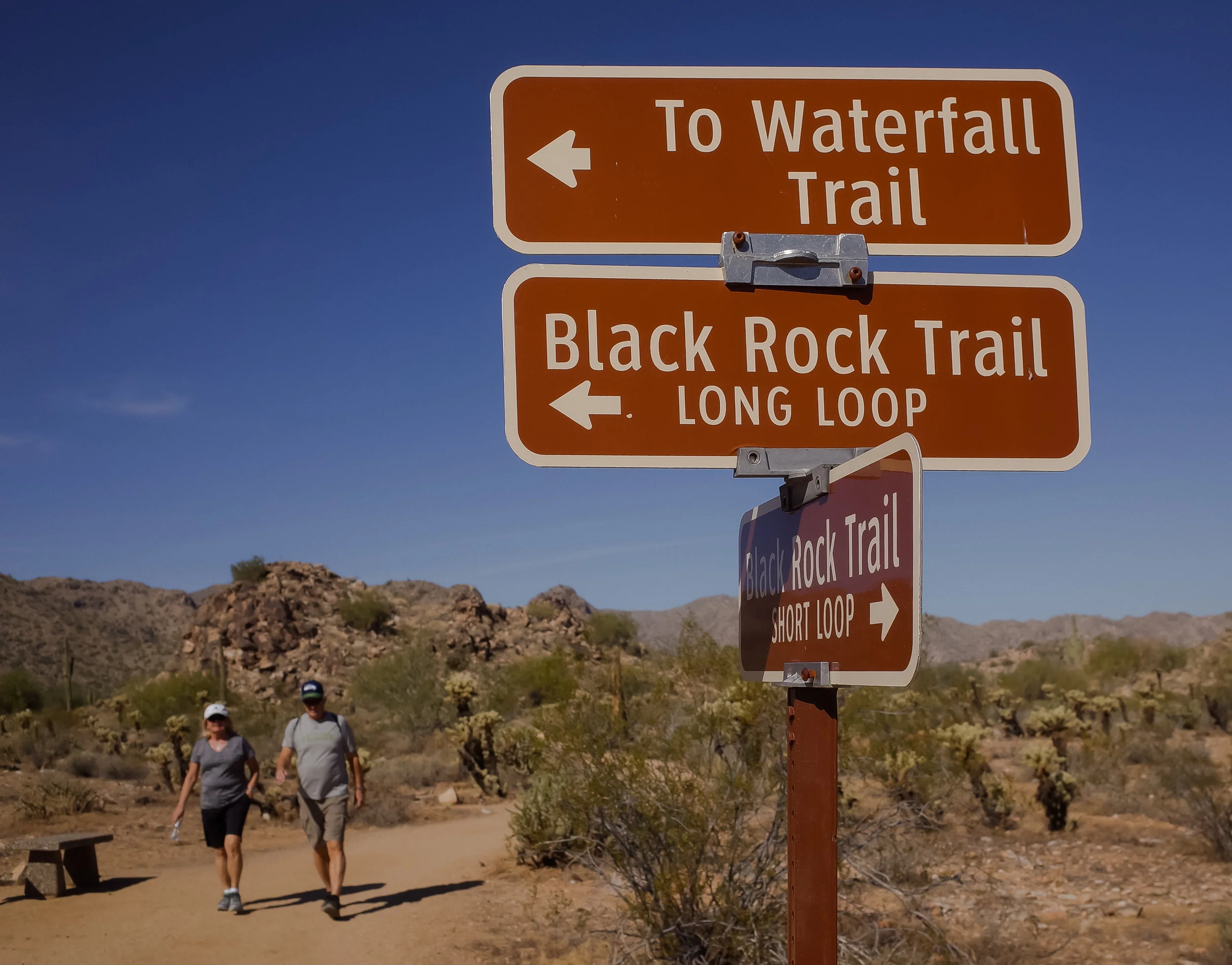


We started our hike on the Waterfall Trail, but you could easily add it to the end of any of the other trails. From the entrance of the park, make a right onto White Tank Mountain Road and then a left onto Waterfall Canyon Road. We parked at the trailhead, which will be on your left-hand side. When I say the trail is “easy,” I mean that it’s actually paved for the first half mile and is incredibly family friendly, even for wheelchairs and strollers. If you’re a history or geology nerd like we are, the signs describing the prehistoric and Native American inhabitants are fascinating as are the extensive petroglyphs carved into boulders. The remaining part of the Waterfall Trail is dirt with a patch of boulders at the end requiring just a little bit of scrambling to reach the waterfall. Phoenix hadn’t seen rain in over a month and there was no cascading water to be found—only a shallow pool of a few inches or so at the canyon wall’s edge. Waterfall or not, the canyon wall is impressive and makes for great photographs. The summit of these mountains rises to a little over 4,000 feet, and the shade from the canyon is the most shade we saw on the trails this day with the exception of the park’s ramadas and an occasional Palo Verde tree. Because of its accessibility, the Waterfall Trail is heavily trafficked.
You could hike back the length of the Waterfall Trail to reach the start of the Mule Deer Trailhead at the Staging Area, but I’d suggest cutting through right at about the halfway point on the Waterfall Trail where you’ll walk along one side of the Black Rock Long Loop (0.5 miles). It’s another easy and interesting trail with interactive information about the area’s wildlife, which is abundant. Once you get to White Tank Mountain Road, cross the street into the large parking lot to catch the Mule Deer Trail on your right. This is actually partway into the trail but not by much. If you save the Waterfall Trail option for last or forego it altogether, you can start right at the Mule Deer Trailhead, which again is at the Staging Area just north on White Tank Mountain Road.
The trail begins with a pretty mellow elevation gain with the difference between the trail’s lowest and highest points being only 143 feet. Though the trail is rated as “moderate,” I’d consider it on the easiest end of that rating. The view from the highest point of the trail offers a panorama of the entire valley—on a clear day, you can make out Four Peaks. We stopped to point out as many landmarks as we could—the University of Phoenix Stadium being the easiest to spot. As we descended the trail, a jackrabbit darted out in front of us. Keep an eye out for other wildlife: snakes, lizards, deer, squirrels, and birds. The remainder of the trail is flat and winds through beautiful examples of Sonoran Desert plant life and past a corral. If it’s open, the Nature Center is worth a visit for a cool drink and to peek at the desert tortoise and snakes on display. You’ll pass the Nature Center right before the trail crosses Olive Avenue and then hooks and ends.
What makes this multi-use trail particularly worthwhile is that it’s an incredibly peaceful, desert hike. We ran into fewer than 10 other hikers on a Sunday afternoon and had the chance to enjoy each other’s company over 9 miles of hiking. Mule Deer Trail would be ideal for families as well as for new hikers/trail runners or those returning to hiking. For more experienced hikers, I’d recommend adding on South Trail and then part or all of Goat Camp Trail, which is rated as extremely difficult.
GETTING THERE
From the north: Take Highway 303 south and exit at Peoria Avenue. Turn right and travel west for 1 mile on Peoria Avenue. Turn left (south) onto Cotton Lane. Turn right (west) on Olive Avenue. Continue 4 miles to the park gate.
From the south: Take Highway 303 north and exit at Northern Avenue. Turn left (west) onto Northern Avenue and travel west for 1 mile. Turn right (north) onto Cotton Lane. Turn left (west) onto Olive Avenue. Continue 4 miles to the park gate.
HIKING TIPS
Park hours allow for stunning views at sunrise and sunset.
The narrow box canyon at the end of Waterfall Trail is worth the visit even when it’s dry, but try to plan a visit after a significant rainfall to see water cascading down the canyon and into the creek bed.
Pack plenty of water and a hat or sunscreen as there is very little shade cover on the trails.
Plenty of trashcans are located at the trailheads. Make sure to leave the park better than you found it.
The building located near the park entrance houses the Nature Center, the Regional Library, and a bookstore. You’ll find vending machines, bathrooms, and drinking fountains. Stop in for a quick visit to the Nature Center to pick up maps, snacks, souvenirs, and trail information.
Hours for the Nature Center are:
- Summer (5/09 - 10/09) Monday thru Saturday: 8 a.m. - 3 p.m. Sunday: Closed
- Winter (10/10 - 5/08) Sunday thru Saturday: 8 a.m. - 4 p.m.
THE NARRATOR
This blog was thoughtfully written by Jia Oak Baker. You can find her on Instagram @violetsky29.
* Please remember to hike at your own risk. To learn more please refer to our Hiking Disclaimer.